|
|
| MONTH | CLIMATOLOGY | 2009 | 2010 |
|---|---|---|---|
| MAY | 30% | 45% | 18% |
| JUN | 36% | 26% | 47% |
| JUL | 29% | 19% | 58% |
| AUG | 24% | 22% | 19% |
This year both June and July had for more low clouds than normal. The plot below shows the daytime low cloud fraction (1.0=100%) at San Diego Lindbergh for each individual day.
Present Year (2010) Low Cloudiness at San Diego Lindbergh
Low Clouds Only (Cloud Base < 2500 ft)
Red Line = Long-term Climatology
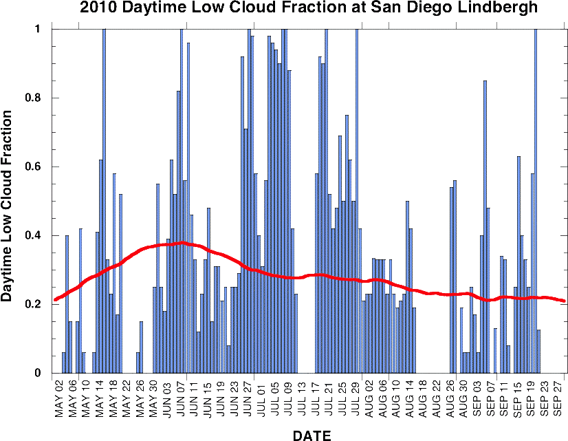
Large amounts of low clouds were present during nearly all of July 2010. No low clouds were observed during a few days in the middle of July which corresponded to a short heatwave induced by a strong high pressure system located over the Southwestern U.S. The low clouds returned once the high pressure weakened and moved east.
These low pressure systems are relatively weak, but they can still impact our weather by increasing the thickness and extent of marine layer clouds. If the low pressure systems are not too strong they will act to raise the inversion layer allowing thicker marine layer clouds to form (if the low pressure systems are too strong they will disrupt the inversion and no marine layer clouds will form). The low pressure systems also increase the onshore (ocean to land) flow which helps bring the marine clouds onto the land areas.
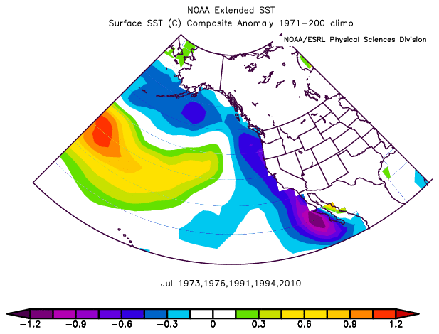
July also saw very cool sea surface temperatures (SSTs) off the Southern California coast as shown in the figure below.

The cool SST acts to increase the strength of the inversion layer making it more likely that marine layer clouds will form. Additionally, the cooler SSTs increase the coast-inland temperature contrast during the day which enhances the strength of the sea-breeze circulation. Near the surface, the sea-breeze is an onshore flow and can help transport marine layer clouds over the Southern California coastal land regions.
The cooler than normal SST was not limited to just Southern California. The plot below shows the SST anomaly over the Eastern Pacific for July 2010. Colder than normal SSTs extended from the southern tip of Baja California north to the Aleutian Islands. It does not appear that this large area of colder than normal SST is associated with the developing La Nina in the tropical Pacific.

This pattern of colder than normal SST along the Pacific coast of North America is often associated with more marine layer clouds here in San Diego. Looking back at historical cloud data at San Diego from 1960-2010 finds that the five Julys with the most marine layer clouds occurred in 1973, 1976, 1991, 1994 and 2010. The average SST anomaly in the Eastern Pacific for these 5 months is shown in the plot below.
The pattern is very similar to what was observed this year with cold SST anomalies up and down the west coast of North America. Despite the consistent pattern of cold SSTs during years with more than normal marine layer clouds in San Diego, it can be difficult to assert that the SSTs are causing the increase in cloudiness. For example, it is possible that the increased amount of clouds are acting to cool the SST by reflecting away more solar radiation than normal.
One way to help separate the cause and effect is to look at the SST anomalies during the month prior to the observed increased marine layer clouds. The plot below averages the SST anomaly for June for the years 1973, 1976, 1991, 1994, and 2010. Once again there is an extensive area negative SST anomalies along the western North American coastline indicating that the cold SSTs were in place the month before the unusually large amounts of low clouds were observed.

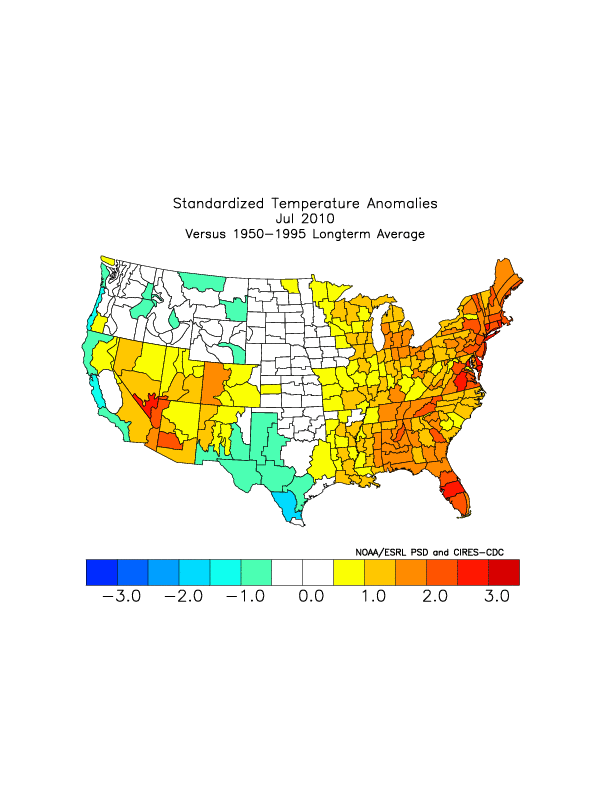
In addition to providing rather gloomy conditions, the large amounts of low clouds over San Diego this July has also kept the temperatures considerably cooler than normal. However, it is important to keep in mind that what happens in San Diego does not necessarily translate to other regions. The plot below shows the surface air temperature anomaly for July 2010. As one might expect, the temperatures along the coast of California were below normal. However, the temperatures in inland areas of California and much of the nation were above normal.