Last update: 1 June 2016
What is a Santa Ana?
The Santa Ana is a dry, sometimes hot and dusty, wind in southwestern California that blows westward through the canyons toward the coastal areas. Santa Anas are a seasonal phenomena, occurring mostly during fall, winter and spring, tending to peak in December. The wind usually has its origin when cold air spills southward into the Great Basin, trapped between the Rockies to the east and the Sierras and Southern California coastal range to the west. This cold air mass is characterized by unusually high pressure near the land surface. Winds are driven into Southern California when the pressure of this interior air mass exceeds the pressure along the California coast. Winds are often strongest in mountain passes which are ducts for the continental air flow. Because the air over the higher elevations of the Great Basin sinks as it flows into coastal California, it is heated adiabatically, and temperatures are often quite warm. This continental air mass is invariably dry, so humidities in Santa Anas are low, often less than 25% relative humidity. Santa Anas have occurred irregularly over the time period since about 1950 when we have collected detailed wind and humidity observations, with some months experiencing Santa Ana conditions 30% the time, and other months less than 5% of the time.Santa Anas have several colorful nicknames including "devil's breath".
What is the historical record of Santa Ana events?
Santa Anas typically occur from October into March. Many associate Santa Anas with autumn because at that time the winds often spread wildfires across areas that have gone months with little or no rain.
Are we currently experiencing Santa Ana conditions?
Current southern California Santa Ana conditions are:
RED = YES Meteorological parameters indicate Santa Ana conditions are occurring
GREEN = NO Meteorological parameters indicate Santa Ana conditions are NOT occurring
Click on the button for details from the last 24 hours:Click here for conditions this month:SAIndex_201606Click here for conditions last month:SAIndex_201605We use an index of three different weather parameters to detect Santa Ana conditions. These parameters are:
- the surface pressure difference (must be relatively high) between weather stations over the Great Basin and those sited along coastal Southern California
- at the coastal Southern California stations, the humidity of the air at or near the surface (must be relatively low)
- the direction of the wind at or near the surface (must be in the sector between north-northwesterly and easterly)
Detailed textual information of the data used to determine our current conditions can be found by clicking on the above condition image.

What atmospheric ciruclation features are associated with Santa Ana events?
Any low-pressure system in the Pacific off the California coast may change the stability of the Great Basin High. The Great Basin High winds then turn southward along the eastern slopes of the Sierras. The low-pressure system over the Pacific literally sucks the winds through the mountain passes of Southern California toward the coastal areas.

Image courtesy NASA
Dusty Skies over Southern California - From NASA Earth Observatory New Images (June 2002)
The following image and news article were taken from the NASA Earth Observatory News site: http://earthobservatory.nasa.gov/Newsroom/NewImages
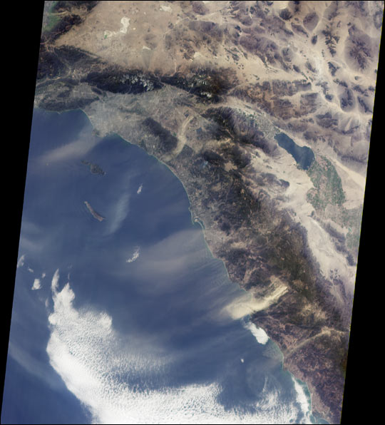
Southern California's "Santa Anas" are dry, north-easterly winds having speeds in excess of 25 knots (46 kilometers/hour). Santa Ana conditions are commonly associated with gusts of more than twice this level. These offshore winds usually occur in late fall and winter when a high pressure system forms in the Great Basin between the Sierra Nevadas and the Rocky Mountains. The air warms as it flows downslope from the high plateau, and its speed increases dramatically when forced through narrow canyons and mountain passes. Due to Southern California's uneven terrain, the strength of the winds varies greatly from place to place, and the Santa Anas can be sufficiently strong to pick up surface dust.
This view from the Multi-angle Imaging SpectroRadiometer shows the pattern of airborne dust stirred up by Santa Ana winds on February 9, 2002. The image is from MISR's 70-degree forward-viewing camera, and airborne particulates are especially visible due to the camera's oblique viewing angle. Southeast of the Los Angeles Basin, a swirl of dust, probably blown through the Banning Pass, curves toward the ocean near Dana Point. The largest dust cloud occurs near Ensenada, in Baja California, Mexico. Also visible in this image is a blue-gray smoke plume from a small fire located near the southern flank of Palomar Mountain in Southern California.
This image represents an area of about 410 kilometers x 511 kilometers. Image courtesy NASA/GSFC/LaRC/JPL, MISR Team.