CAP Meeting
2 December 1998
Scripps Institution of Oceanography
Predicting ENSO Impacts on Intraseasonal Precipitation Statistics
in California: The 1997-98 Event
T.P. Barnett, A. Gershunov and D.C. Cayan
Climate Research Division
Scripps Institution of Oceanography
ABSTRACT
ENSO has a significant effect on seasonal statistics of high frequency
precipitation and temperature (e.g. frequencies of extremes) in both
observations and GCMs. GCMs, however, do not simulate realistically the
spatial features over the United States of the ENSO signal in
high frequency weather. On the other hand, they do a reasonable job
simulating ENSO signals in monthly or seasonal averages of such
well-behaved variables as geopotential heights. The question we pose is
can the large scale abilities of the GCMs be used with observations, in a
statistical downscaling scheme, to produce useful GCM-derived intraseasonal
climate statistics.
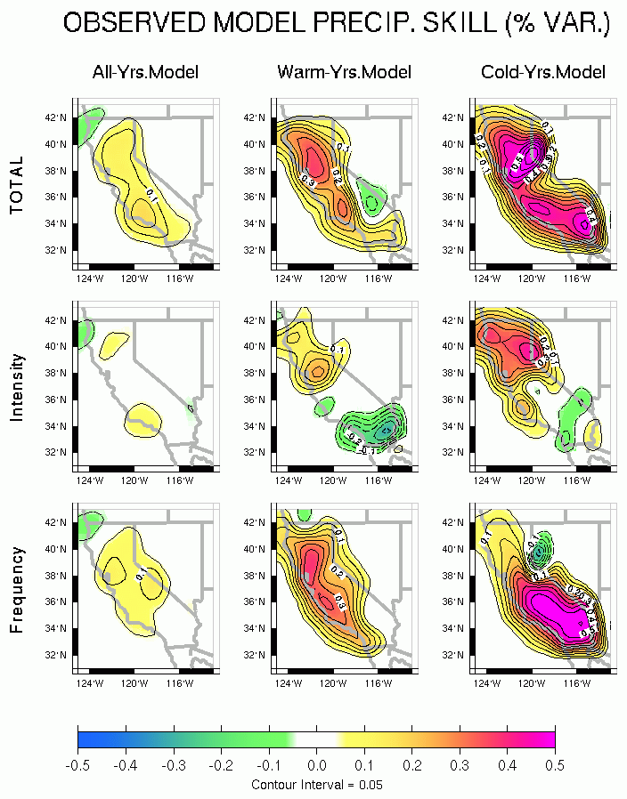
Observed 700mb geopotential heights have been used to to create a Hybrid
model that estimates precipitation total, intensity and frequency. This
model shows considerable skill during extreme ENSO events (
Figure 1 ).
Forecasts of heavy rainfall frequency are made by
two models of differing complexity: (a) straight statistical forecast
based on a simple ENSO index and daily observations from
1950-1995 (Statistical) and
(b) statistically downscaled GCM forecast going from geopotential height
anomalies to the same set of intraseasonal metrics as in (a) (Hybrid). Looking
at the El Nino JFMs on record, the Hybrid model contributes significantly
to the forecast skill when looking at the precipitation total, intensity and
and frequency (
Figure 2 ).
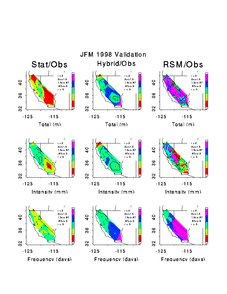
As a case study, we will present forecasts of heavy rainfall frequency
for JFM 1998.
We compare the Statistical and Hybrid models with a dynamically downscaled GCM
forecast made by a nested regional model. To the left is shown the
precipitation intensity for the Hybrid model compared to
observations. The green region shows where the model is in good agreement
with observations (within 50 percent).
The yellow and red areas show where the model
underestimates precipitation and the blue and purple areas show where the
model overestimates precipitation. This image illustrates the good agreement
between the Hybrid model and observations for JFM 1998.
In this case the use of the
nested regional model does not add to the forecast skill (
Figure 3 ).
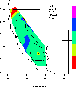
A forecast for JFM 1999 from the statistical model indicates a
drier-than-normal season for southern California (
Figure 4 ).
Figures
Figure 1 shows the skill of the observed 700mb geopotential height model
in explaining precipitation total, intensity and frequency in percent
variance for all years, warm years and cold years.
Figure 2 shows the skill in proportion of variance explained by the purely
Statistical model (tropical Pacific SST - California rainfall) and the
Hybrid model (GCM 700mb heights and statistical downscaling to the three
precipitation variables) for the El Nino JFMs on record. This is a
cross-validated measure, so negative values are possible where no skill
is present. Only positive values are plotted in color and with contours at
.1 intervals.
Figure 3 shows the ratio of the JFM 1998 forecasts to observations from the
three approaches (Statistical, Hybrid and Dynamical - columns) for the
three rainfall variables (rows). The heavy contour is ratio = 1. Green color
represents forecast agreement to within 50 percent of observations.
Yellow and red (blue and purple) are underestimations (overestimations)
of between 50-100 percent and over 100 percent, respectively.
Figure 4 shows the JFM 1999 forecast from the Statistical model. Anomalies
are shown in the left column in units of probability of being larger than
a random observation from the local 1950-1995 climatology. The 0.5 (the
median) contour is thickened. Larger (wetter) values are solid, smaller
(drier) values are dashed at 0.1 intervals. The middle column represents
total forecast fields (as opposed to anomalies). The right column shows
the cross-validated skill associated with this La Nina forecast.