Traditional scientific visualization tools do not necessarily resolve this question. The problem is that subtleties of numerical models often come out in relationships between predicted variables rather than in the behavior of the variables themselves. While nothing prevents a general visualization package from displaying these relationships, in practice this usually means that the data must be separately analyzed before being visualized, a time-consuming task.
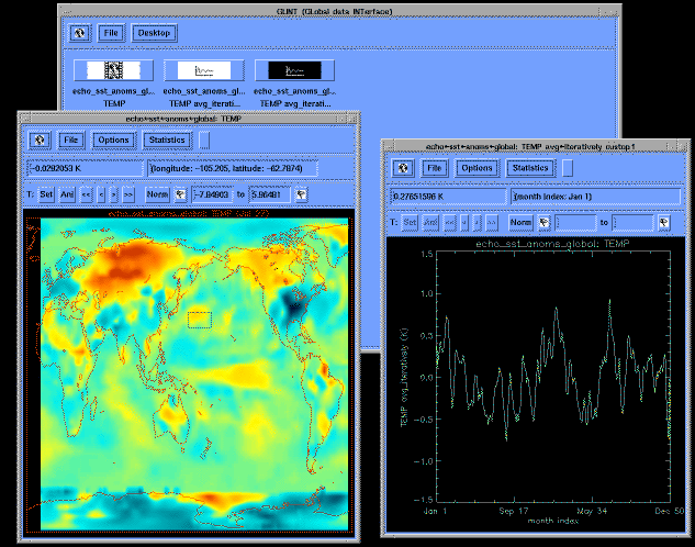
At the Climate Research Division of the Scripps Institution of Oceanography in La Jolla, California, we have tried to address some of these issues by developing a software package that integrates statistical tools and underlying support for geophysical data into the framework of a point-and-click visualization tool. The Glint package (for "global data interface") was conceived by climatologist Tim Barnett and implemented by Ben Stephens, then a high school student at Torrey Pines High School in La Jolla, and myself. Glint is an extensive set of subroutines atop the IDL computing environment, which provides a high-level, platform-independent set of graphical and statistical routines.
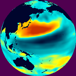
On the cover is an image, computed and visualized by GLINT, showing a region in the Pacific Ocean over which sea surface temperatures tend to vary in a cohesive pattern. The raw data came from a 100-year run of Echo, a sophisticated coupled model of global ocean-atmosphere general circulation developed at the Max-Planck-Institut in Hamburg, Germany. Echo calculates the evolution of the ocean and atmosphere characteristics on a global grid with a resolution of about 270 kilometers in mid-latitudes and finer resolution in the tropics. There are 19 layers in the atmosphere model and 12 in the ocean model; the atmosphere uses a 25-minute time step, the ocean a 6-hour time step. The model took a year of CPU time on various Cray Y-MPs. Analyzing the results, Mojib Latif and Tim Barnett (1994) showed that the model simulates both the observed average climate and the size of typical year-to-year variations around the average. The purpose of such a run is not to specifically predict what the climate will be in, say, 32 years, but rather to try to understand the forces at work in producing departures from the mean climate, the size of those variations, and their expected frequency and duration.
Glint was used to make the cover image by first calculating Echo's sea surface temperature anomaly field, which is the instantaneous departure from the climatological average at each point. This is accomplished simply by choosing an option from Glint's Statistics menu, which contains a user-extensible set of routines designed for such calculations. Next a region of interest, in this case the central Pacific, was selected by drawing a box on the image with the mouse. Other statistics modules averaged the data over the selected region, resulting in a 100-year time series, and smoothed it with a 9-month running mean filter (Figure 1).
Following Glint's philosophy that relationships between variables should be easily visualized, a final module correlated the smoothed time series to the full set of global temperature anomalies. The resulting distribution of correlation coefficients is shown on the cover; red shows unseasonably warm regions and blue shows unseasonably cold ones (when this climate pattern is strong). According to Latif and Barnett, this pattern arises from the way the Pacific Ocean upper circulation carries temperature anomalies in a clockwise pattern, and from the way ocean surface temperature gradients, modified by the temperature anomalies, have a varying influence on the local winds.
An important design goal was to provide easy-to-use tools for extending analysis. For example, what influence does this Pacific Ocean process have on the climate in North America? Echo runs showed that the atmosphere's main response to the ocean surface temperature pattern pictured on the cover is to generate high-pressure anomalies over the Aleutian islands. Glint was used to construct a time series of anomalous atmospheric pressures around the Aleutians from the model data. To see what influence this had on winter temperatures over North America, the time series was correlated to Echo's two-meter air temperature data in the region. The result is shown in the left panel of Figure 2.
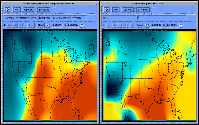
An especially useful feature of Glint is that it comes with many ocean-atmosphere data sets already converted to the proper format (NetCDF), which makes comparing model results with observed data relatively easy. For instance, as Figure 2 shows, the model result just described can be visually compared with empirical data. The right-hand side of the figure shows the result of correlating observed atmospheric pressures over the Pacific (Trenberth and Hurrell 1994) to air temperatures from the Climate Research Unit at the University of East Anglia, UK. The pattern agrees well with that of the numerical model on the left, with negative correlations along the west coast and positive correlations in the southeastern U. S., although the magnitudes are smaller.
Glint can also decompose a time series into empirical orthogonal functions and principal components. EOFs form an orthogonal basis set from which a field can be reconstructed, with the time-dependent strength of each EOF given by its associated principal component; they can be ranked according to how much of the data's variability they explain. Figure 3 shows the leading EOF calculated from Pacific Ocean surface temperatues during the 1980s; the red areas occasionally warmed, while the blue areas had little temperature variability. The pattern is that of El Nino, a coherent warming of the Pacific Ocean which starts at the west coast of South America and stretches thousands of kilometers along the equator. The El Nino of late 1982 and early 1983 was particularly intense and caused widespread climate perturbations over North America.

We have been using Glint internally on DEC Alpha workstations for about six months, and hope to start distributing it soon to other sites. We are continuing to improve its functionality and fix bugs. Readers who are interested in trying GLINT may request a copy via e-mail to glint@cirrus.ucsd.edu. Glint requires IDL version 3.6.1 or later (from Research Systems Inc., Boulder, Colo.), which can run on 486-based PCs and Macintoshes as well as workstations and supercomputers. A group at the Jet Propulsion Laboratory is working on adapting Glint to HDF, the data format standard used by the EOS project.
The work described here was made possible in part by grant NSF ATM93-14495 from the Atmospheric Sciences Division of the National Science Foundation, grant NAGW-1952 from NASA, and Department of Energy CHAMMP grant DE-FG03-91-ER61215.
Latif, M., and Barnett, T. P., 1994: Causes of Decadal Climate Variability over the North Pacific and North America. Science, v. 266, pp. 634-637.
Trenberth, K. E., and Hurrell, J. W., 1994: Decadal atmosphere-ocean variations in the Pacific. Climate Dynamics, v. 9, pp. 303-319.

Back to David Pierce's home page.
Last modified November 15, 1995