
Figure 1 shows the salinity 10 years after the run begins, at a depth of 700 meters (near the final outflow depth, including entrained water).
The initial location of the outflow water is clearly evident. I should mention that "outflow water" in this context always means the water after the effects of entrainment have been added. The way I added the MSM to the LSG, only the final product water, after the entrainment process has occurred, is relevant.
The salinity at year 70 is shown in Figure 2.

One branch of the Med Sea outflow has flowed north along the coast, almost reaching Iceland. Another, broader portion is directly filling the North Atlantic.
This pattern with two branches continues; Figure 3 shows the salinity after 110 years, when the Med Sea has infiltrated the GIN sea and begun to affect the NADW.

The influence of the Med water on the NADW by year 150 can be seen in a east-west transect along 37.5 N, which is shown in Figure 4.
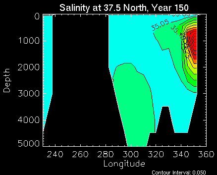
The NADW core, flowing South along the east coast of the U.S., shows up as a region of elevated salinity due to mixing-in of the Med water. The Med water itself is the high-salinity water mass flowing north on the eastern side of the basin.
This Med-salinified water goes on to fill up the entire world ocean. Figure 5 shows a time series of salinity at 3000 meters, with the interval between frames being 100 years.

It is easy to see how the Med water, carried by the NADW at this depth, goes eastward around the tip of Africa, and gets advected into the Pacific basin by the ACC.
Finally, a profile of velocities into and out of the marginal sea, as calculated by the MSM, is shown in Figure 6.

The strong, shallow flow into the marginal sea can be seen, as well as the broad outflow of water after the entrainment process has been added in. The slight "shoulder" on the inflow peak shows the inflowing water which is entrained into the descending plume.